Thursday, August 4, 2011

CASSON AND THE CONROY MARSH - PART 5

After checking out the duck blind, and about ninety minutes on the water, we turned around and began to head back to our put in at Mayhew Landing. Unfortunately, nothing of the scene depicted in Casson's painting could be identified specifically, however the painting had a number of elements that we did see examples of on our paddle. We covered about one-third of the length of the Marsh, so it is quite possible the scene depicted was at the western end, somewhere near where the York River enters the marsh, as we have entered via the Little Mississippi, and I could not recognice the scene there either.


Noodling through the grasses and lilypads, looking north toward the hill at Craigmont, the location of an old corundum mine.


Very little of the land bordering the marsh is privately owned, virtually all is crown land, except for this obvious location,


A close up view of the blight on the landscape. A more thoughtful owner could have done a better job clearing


Rudi looking back as we head toward Negeek Lake and the take out.

Wednesday, August 3, 2011

CASSON AND THE CONROY MARSH - PART 4

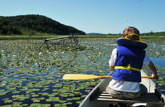
A further half hour of paddling and noodling around brought us to another large 'lakelet' just to the south of the main channel. A few hundred metres ahead I could make out a small structure, of wooden poles fastned together. We paddled over to it, the water generally about a foot deep here, and took a closer look. My first guess from its size was that it was a hunting blind, as it was large enough to park a small aluminum boat in.


Looking southwest, the Craigmont hill is just out of the frame to the right. The main channel carves an arc from behind us, out to our right a few hundred feet, and then cuts across to the left just past the grasses at the near horizon.


A close up of what I think is a duck hunting blind. I have no idea what age, it could be decades old. I am not sure how much human traffic enters the marsh, though it could be as little as a few each day.

Tuesday, August 2, 2011

CASSON AND THE CONROY MARSH - PART 3

After playing leapfrog with the Beaver for a few more minutes, we continued paddling westward, exploring the marsh areas to the north of the main channel. The water level of the Marsh is controlled by the Palmer Rapids control dam, which is one of a series of several dams on the Madawaska river that are situated and operated to control water levels for the 'large' hydroelectric dam at Arnprior on the Madawaska, near its outlet into the Ottawa River.

The Marsh level, based on some reading, is roughly four feet higher than prior to the installation of the control dam, and must have altered the habitat and ecosystems of the Marsh to a degree. Currently, the marsh has a river channel that varies between 100 and 300 feet wide or more, which is quite deep, upwards of 10 to 20 feet in most places. The rest of the marsh appears to be made up of two different ecosystems: Flooded shallow lake areas, with a water depth between one and four feet deep, thick with water lillies and other fully aquatic plants; and fully saturated areas with ground that rises slightly above the water level, completely covered in wet loving grasses and sedges.


Looking south west into the Conroy Marsh. About two miles ahead, past the near hill on the left, is the entry of the Little Mississippi River. The York River opens into the marsh about five miles directly ahead.


Looking to the west now, and Craigmont Hill. We are paddling in the shallow flooded areas, which are populated with lilies and other aquatic plants. Directly ahead are grasses that stand at water level or therabouts, I imagine it could be possible to walk through them, if you enjoy being knee deep in muck.


Looking west still, and now we are on the extreme south shore of the Marsh, in the main river channel. The small spot on the hill ahead is likely the opening of the shaft of the Craigmont Mine.

Monday, August 1, 2011

CASSON AND THE CONROY MARSH - PART 2

After stopping in Combermere at the internet hotspot / cafe / laundromat for a maple blend coffee and to find out if there is a fair place to put on the north side of the Conroy Marsh, we drove south on old highway 517 and then Lower Craigmont road to the hamlet of Mayhew Landing. Unlike the vast majority of Ontario cottage country, the road access here was on the lake side of the waterfront properties, and in Ontario would generally be considered a public allowance: I tried knocking on two of the cottages closest to the end of the road to ask if we could use their waterfront or even dock to put in, though there was no answer. We took our gear and canoe to the first dock, and loaded up.

Immediately looking out to the left, the marsh continued just a few hundred metres before opening into Negeek Lake on the Madawaska River. This is where the marsh channel, actually the York River, ends and empties into the Mighty Madawaska.

We turned west, and paddled into the marsh, which stretched away at least five miles in front of us. Just fifteen minutes of easy paddling brought us to a large beaver lodge. As we approached within about fifty feet, there was a quick flash of brown, and a large slap of a beaver tail against water! Knowing that they were aware of us now, we turned to the left and away from the lodge. Immediately beneath and to the right of the canoe there was a large turbulence of the bottom silt, with large clouds of muck roiling away underneath and alongside the canoe, moving ahead as we paddled forward. A panicked thought of  mammoth canoe tipping beavers flashed into my mind, quickly dispelled of course! Within half a minute, a brown head popped up fifty yards ahead of the canoe! We paddled towards it, and after closing half the distance, he dove under, only to appear a few hundred feet further along. 


Looking east from Mayhew Landing, across the York River, and the outlet of the Conroy Marsh, to the hills across Negeek Lake (hidden from view behing the low bank of green).


Paddling westerly, about 500 metres from Mayhew Landing. A large beaver lodge is ahead of the canoe. The 'mountain' in the background is about two to three miles away, and is the location of the historic Craigmont corundum mine.


A close up of the beaver lodge, The Conroy Marsh enables lazy beavers, as they do not have to do any dam building whatsoever..

LinkWithin

Related Posts with Thumbnails