Showing posts with label Rapids. Show all posts

Thursday, October 10, 2019

TRIP PLANNING FOR THE BARRON CANYON, THE CASCADES, HIGH FALLS


BARRON CANYON DAY TRIP:
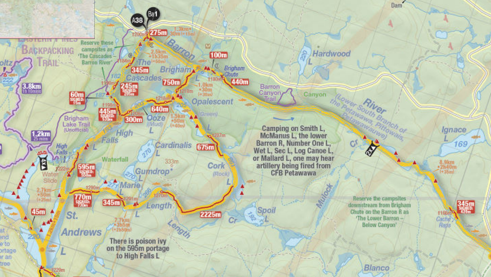
A fairly easy and spectacular day trip into the Barron Canyon can be done by driving to the small Brigham Lake parking lot, putting in, and following the Barron River downstream into the Barron Canyon.  If you paddle just the length of the canyon and then return, it is about four hours. If you make it to Cache Rapids (worth seeing) the round trip can be six or seven hours. Add in a hike of the Barron Canyon trail, and you have a solid day.

THE CASCADES / HIGH FALLS DAY TRIP:
A nice one day up the cascades to high falls starts by parking at the Brigham Lake lot, and putting in but going upstream along 'The Cascades'. Four portages will get you to High Falls lake, which is beautiful, and after paddling the length of the lake, you can explore the main portage along the river to St. Andrews Lake, or the side trail to check out High Falls.  If you hit the water by nine in the morning, you can lunch at the take out at High Falls, and get back to your car by three or four in the afternoon.

SINGLE NIGHT TRIP:
Book a campsite on Opalescent Lake, put in at Brigham Lake, paddling to your campsite and setting up camp,  return to the Barron River light, and spend the rest of the day exploring the canyon, at least to Cache Rapids, then return to Opalescent for the night.
The next morning, leave opalescent lake light, and head for High Falls via Ooze Lake and High Falls Lake. once you have checked out the falls, return to Opalescent via the cascades and Brigham lake, break your camp, and then head back to your car at the Brigham Lake lot

Saturday, September 5, 2009

THE BARRON CANYON (PART 3)


Well, seeing as I have five thousand words worth of pictures here, I will let them tell the story, click on any of them to enlarge (try to find the other canoe hidden in one of the photos - first correct answer posted gets a free nights stay at the Field House Bed and Breakfast in beautiful Tavistock Ontario!):


Thursday, September 3, 2009

THE BARRON CANYON (PART 2)


After hiking the trail above the Barron Canyon, Rudi and I got back to the van and drove to the Brigham Lake parking lot, about 5km further up the road. Within a few minutes the canoe was offloaded, and we were heading down a fairly steep little trail toward the water, Rudi carrying the backpack and paddles, and me the canoe. We arrived at the put in, just below a small rapid, where a couple were relaxing, their canoe tucked just out of the way. By the time we loaded up and got in the water (and I returned to the van for my camera!) they were also getting ready to go. What then followed was a low speed canoe chase, which Rudi and I eventually lost! The first picture is a view looking East, downstream toward the canyon, with the couple who just passed us about fifty yards ahead. Here the canyon walls rise about 200 feet, but are well back from the river, and are simply steep, tree covered slopes. This small river section is about 1km long, and empties into Brigham lake, which is quite small, the far end of which is the first portage. The second photograph is a view looking back to the West, and Brigham Lake, where we had just landed at the take out for the first portage. The portage was only a hundred metres, and led us past some rapids, into a very small lake, which we crossed to find the takeout for the second portage. We paddled across the front of the outlet of this little lake, taking a peek over the steep set of rapids that led to Brigham falls. This portage was 440m in length, and It was a fair bit of effort raising the canoe, as it was the Fibreglass Prospector, and weighed just under 60lbs. The third photograph was taken with the canoe on my shoulders (look carefully at the strange dark part of the top of the photo, it is the inside of the canoe.) and is looking down Brigham chute, again toward the East. After this final portage, it was just some easy flatwater canoeing right into the heart of the Canyon.

Tuesday, August 11, 2009

THE LITTLE MISSISSIPPI RIVER


After visiting SlipStream Yokes, Rudi and I headed West from Palmer Rapids on Burnt Bridge Road to the bridge over the Little Mississippi River. From the bridge the Little Mississippi flows North two kilometres to enter the Conroy Marsh and meet the York River, and South it meanders upstream toward MacArthur Mills on highway 28, about 20 kilometres away. This time we had our H2O Composites Prospector 16 in fibreglass, a nice boat that turns on a dime compared to the Canadian 16-6. We put in at the boat ramp on the West bank of the river North of the bridge (top photo) then paddled under the bridge, and headed upstream. Not that there was any particularly noticeable flow, I am guessing the river is pretty much flat for miles in any given direction, until it hits a series of rapids, chutes, or falls. We played leapfrog with a Great Blue Heron, who followed us up the river a way.

LinkWithin

Related Posts with Thumbnails